- Home
- Quintessential Queensland
- Distinctiveness
- Perceptions
- Perceptions: how people understand the landscape
- From runs to closer settlement
- Geological survey of Queensland
- Mapping a new colony, 1860-80
- Mapping the Torres Strait: from TI to Magani Malu and Zenadh Kes
- Order in Paradise: a colonial gold field
- Queensland atlas, 1865
- Queensland mapping since 1900
- Queensland: the slogan state
- Rainforests of North Queensland
- Walkabout
- Queenslanders
- Queenslanders: people in the landscape
- Aboriginal heroes: episodes in the colonial landscape
- Australian South Sea Islanders
- Cane fields and solidarity in the multiethnic north
- Chinatowns
- Colonial immigration to Queensland
- Greek Cafés in the landscape of Queensland
- Hispanics and human rights in Queensland’s public spaces
- Italians in north Queensland
- Lebanese in rural Queensland
- Queensland clothing
- Queensland for ‘the best kind of population, primary producers’
- Too remote, too primitive and too expensive: Scandinavian settlers in colonial Queensland
- Distance
- Movement
- Movement: how people move through the landscape
- Air travel in Queensland
- Bicycling through Brisbane, 1896
- Cobb & Co
- Journey to Hayman Island, 1938
- Law and story-strings
- Mobile kids: children’s explorations of Cherbourg
- Movable heritage of North Queensland
- Passages to India: military linkages with Queensland
- The Queen in Queensland, 1954
- Transient Chinese in colonial Queensland
- Travelling times by rail
- Pathways
- Pathways: how things move through the landscape and where they are made
- Aboriginal dreaming paths and trading ways
- Chinese traders in the nineteenth century
- Introducing the cane toad
- Pituri bag
- Press and the media
- Radio in Queensland
- Red Cross Society and World War I in Queensland
- The telephone in Queensland
- Where did the trams go?
- ‘A little bit of love for me and a murder for my old man’: the Queensland Bush Book Club
- Movement
- Division
- Separation
- Separation: divisions in the landscape
- Asylums in the landscape
- Brisbane River
- Changing landscape of radicalism
- Civil government boundaries
- Convict Brisbane
- Dividing Queensland - Pauline Hanson’s One Nation Party
- High water mark: the shifting electoral landscape 2001-12
- Hospitals in the landscape
- Indigenous health
- Palm Island
- Secession movements
- Separate spheres: gender and dress codes
- Separating land, separating culture
- Stone walls do a prison make: law on the landscape
- The 1967 Referendum – the State comes together?
- Utopian communities
- Whiteness in the tropics
- Conflict
- Conflict: how people contest the landscape
- A tale of two elections – One Nation and political protest
- Battle of Brisbane – Australian masculinity under threat
- Dangerous spaces - youth politics in Brisbane, 1960s-70s
- Fortress Queensland 1942-45
- Grassy hills: colonial defence and coastal forts
- Great Shearers’ Strike of 1891
- Iwasaki project
- Johannes Bjelke-Petersen: straddling a barbed wire fence
- Mount Etna: Queensland's longest environmental conflict
- Native Police
- Skyrail Cairns (Research notes)
- Staunch but conservative – the trade union movement in Rockhampton
- The Chinese question
- Thomas Wentworth Wills and Cullin-la-ringo Station
- Separation
- Dreaming
- Imagination
- Imagination: how people have imagined Queensland
- Brisbane River and Moreton Bay: Thomas Welsby
- Changing views of the Glasshouse Mountains
- Imagining Queensland in film and television production
- Jacaranda
- Literary mapping of Brisbane in the 1990s
- Looking at Mount Coot-tha
- Mapping the Macqueen farm
- Mapping the mythic: Hugh Sawrey's ‘outback’
- People’s Republic of Woodford
- Poinsettia city: Brisbane’s flower
- The Pineapple Girl
- The writers of Tamborine Mountain
- Vance and Nettie Palmer
- Memory
- Memory: how people remember the landscape
- Anna Wickham: the memory of a moment
- Berajondo and Mill Point: remembering place and landscape
- Cemeteries in the landscape
- Landscapes of memory: Tjapukai Dance Theatre and Laura Festival
- Monuments and memory: T.J. Byrnes and T.J. Ryan
- Out where the dead towns lie
- Queensland in miniature: the Brisbane Exhibition
- Roadside ++++ memorials
- Shipwrecks as graves
- The Dame in the tropics: Nellie Melba
- Tinnenburra
- Vanished heritage
- War memorials
- Curiosity
- Curiosity: knowledge through the landscape
- A playground for science: Great Barrier Reef
- Duboisia hopwoodii: a colonial curiosity
- Great Artesian Basin: water from deeper down
- In search of Landsborough
- James Cook’s hundred days in Queensland
- Mutual curiosity – Aboriginal people and explorers
- Queensland Acclimatisation Society
- Queensland’s own sea monster: a curious tale of loss and regret
- St Lucia: degrees of landscape
- Townsville’s Mount St John Zoo
- Imagination
- Development
- Exploitation
- Transformation
- Transformation: how the landscape has changed and been modified
- Cultivation
- Empire and agribusiness: the Australian Mercantile Land and Finance Company
- Gold
- Kill, cure, or strangle: Atherton Tablelands
- National parks in Queensland
- Pastoralism 1860s–1915
- Prickly pear
- Repurchasing estates: the transformation of Durundur
- Soil
- Sugar
- Sunshine Coast
- The Brigalow
- Walter Reid Cultural Centre, Rockhampton: back again
- Survival
- Survival: how the landscape impacts on people
- Brisbane floods: 1893 to the summer of sorrow
- City of the Damned: how the media embraced the Brisbane floods
- Depression era
- Did Clem Jones save Brisbane from flood?
- Droughts and floods and rail
- Missions and reserves
- Queensland British Food Corporation
- Rockhampton’s great flood of 1918
- Station homesteads
- Tropical cyclones
- Wreck of the Quetta
- Pleasure
- Pleasure: how people enjoy the landscape
- Bushwalking in Queensland
- Cherbourg that’s my home: celebrating landscape through song
- Creating rural attractions
- Festivals
- Queer pleasure: masculinity, male homosexuality and public space
- Railway refreshment rooms
- Regional cinema
- Schoolies week: a festival of misrule
- The sporting landscape
- Visiting the Great Barrier Reef
By:
Maurice French Black soil and ‘rolling grass seas’
The quintessential Darling Downs landscape of the nineteenth century was characterised by black soil and ‘rolling grass seas’ which held the sheep, woolsheds and large pastoral stations of wealthy squatters. One of Queensland's most productive pastoral areas, it became celebrated in both art and literature.
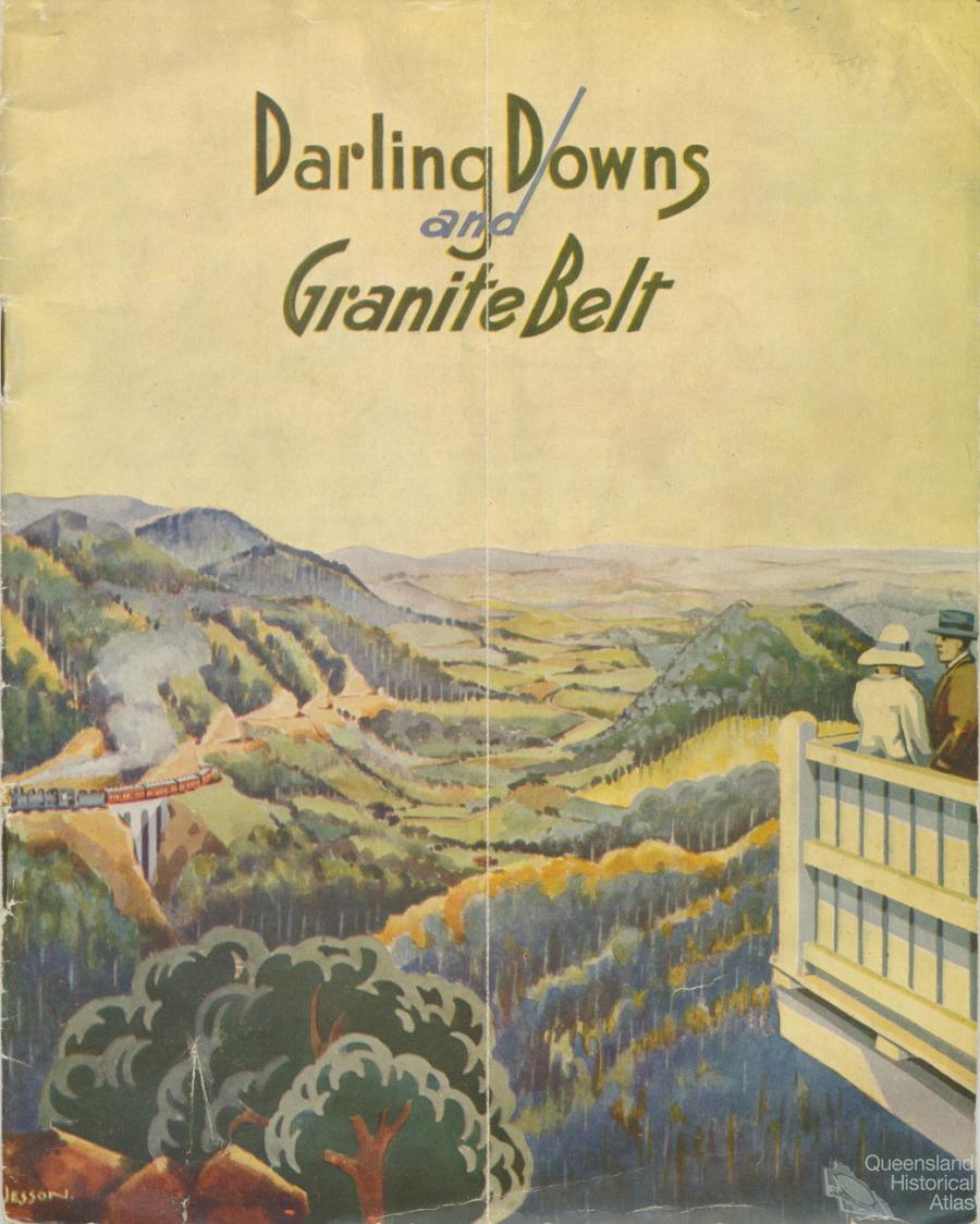
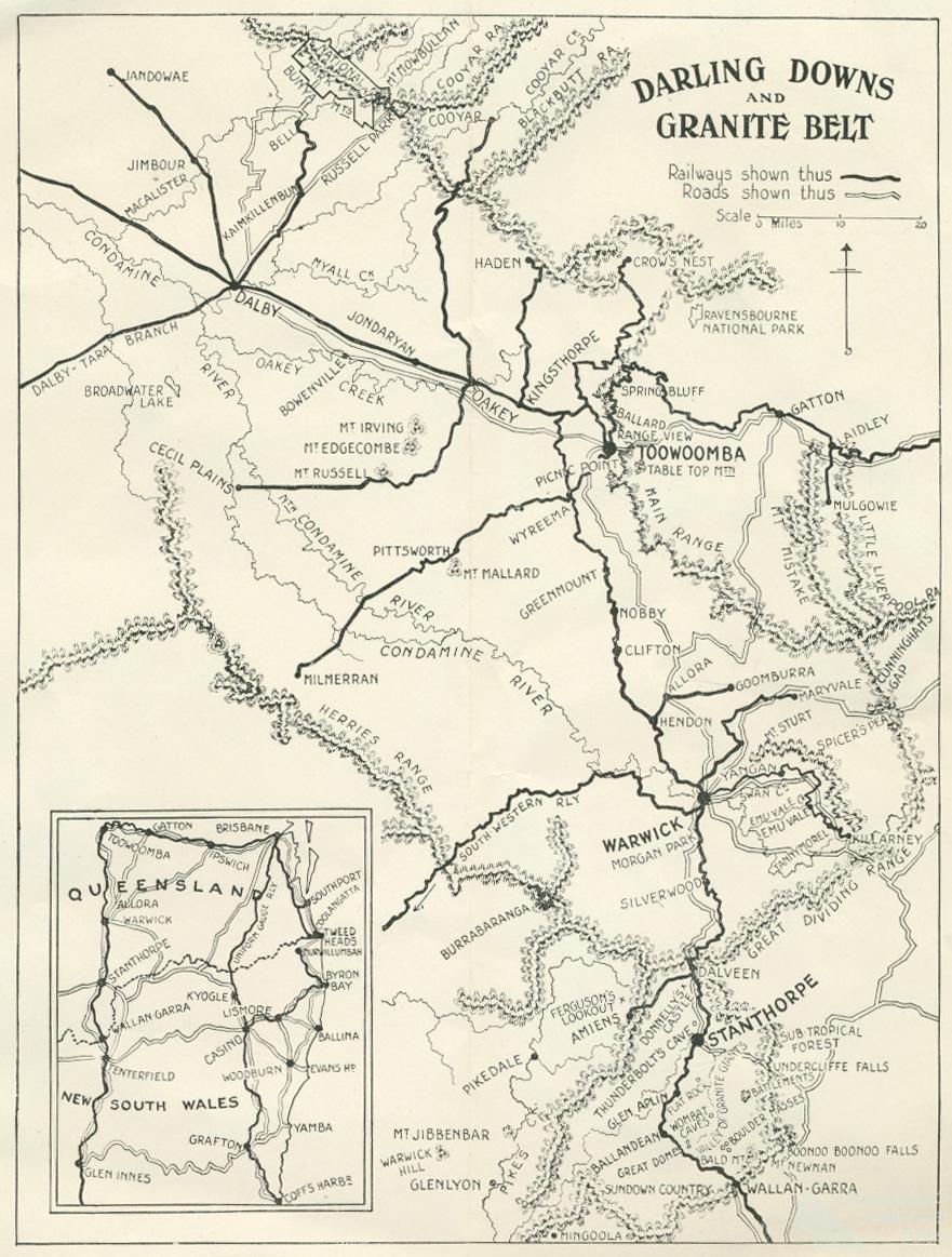
The Darling Downs is complex and difficult to define and locate on a map, being between 130-250 km west of Brisbane. Ranging from 500 m to 650 m above sea level, it is a distinctive cool region of Queensland bounded in the north by the Bunya Mountains, in the east by the Great Dividing Range, in the south by the Granite Belt and Herries Range, and on the west by the Condamine River. Initially part of a vast, shallow inland sea, a series of volcanic eruptions over millions of years formed heavy clay sheets around Dalby and Chincilla, the red soils around Toowoomba, the stony clay soils near Stanthorpe, the heavy black soils of the extensive Condamine River flood plain and the distinctive round, flat-topped basalt cones – ‘sugarloafs’ – that stand as sentinels in the open, well-grassed plains. Explorer Ludwig Leichhardt described the region in a letter of 27 March 1844:
Ranges of middling height, now a chain of cones, now flat-topped mountains covered with brush … accompany on each side the plains two to three miles broad, and many miles long. The soil is black … the vegetation is quite different from … the other side of the coast range; the grasses more various … The creeks are deeply cut, with steep covered with reeds.
He described the Condamine alluvial plain thus: ‘I crossed one of them twenty-five miles broad, and fifty miles long, a true savannah, in the centre of which I saw the sharp line of the horizon, as if I had been on an ocean’.
For thousands of years this upland landscape was home to perhaps 1500 members of the Keinjan, Giabal, Jarowair and Barunggam tribes, a subset of the Wacca Wacca language speakers. The Jarowair were custodians of the Bunya Mountains where, triennially, they invited indigenous peoples from southern Queensland and northern New South Wales to take part in a festival: feasting on the protein-rich bunya nuts, settling disputes, performing song-cycles and, most importantly, exchanging intelligence about the coming of the white men and their strange animals.
Jewel in the diadem of squatterdom
Although ‘discovered’ by Allan Cunningham in 1827, and named after Sir Ralph Darling, Governor of New South Wales (1825-31) the Downs was not settled by Europeans until 1840 but within two decades the region had become the ‘jewel in the diadem of squatterdom’ and the squatters the elite of the ‘pure merinos’; pastoral villages dominated by comfortable houses and large woolsheds then dotted the landscape. In the next three decades, however, agricultural selection or family farming – especially attractive to German and Irish immigrants – would ineluctably challenge pastoralism despite dummying, debt, drought and depression. It became commercially-viable on the eve of World War I with the advent of refrigeration and a branch railway network that spread, web-like, into every little valley; the native grasses were now replaced by wheat and lucerne; the landscape was dotted with butter and cheese factories and the iconic Southern Cross windmill, manufactured in Toowoomba.
Garden of Queensland
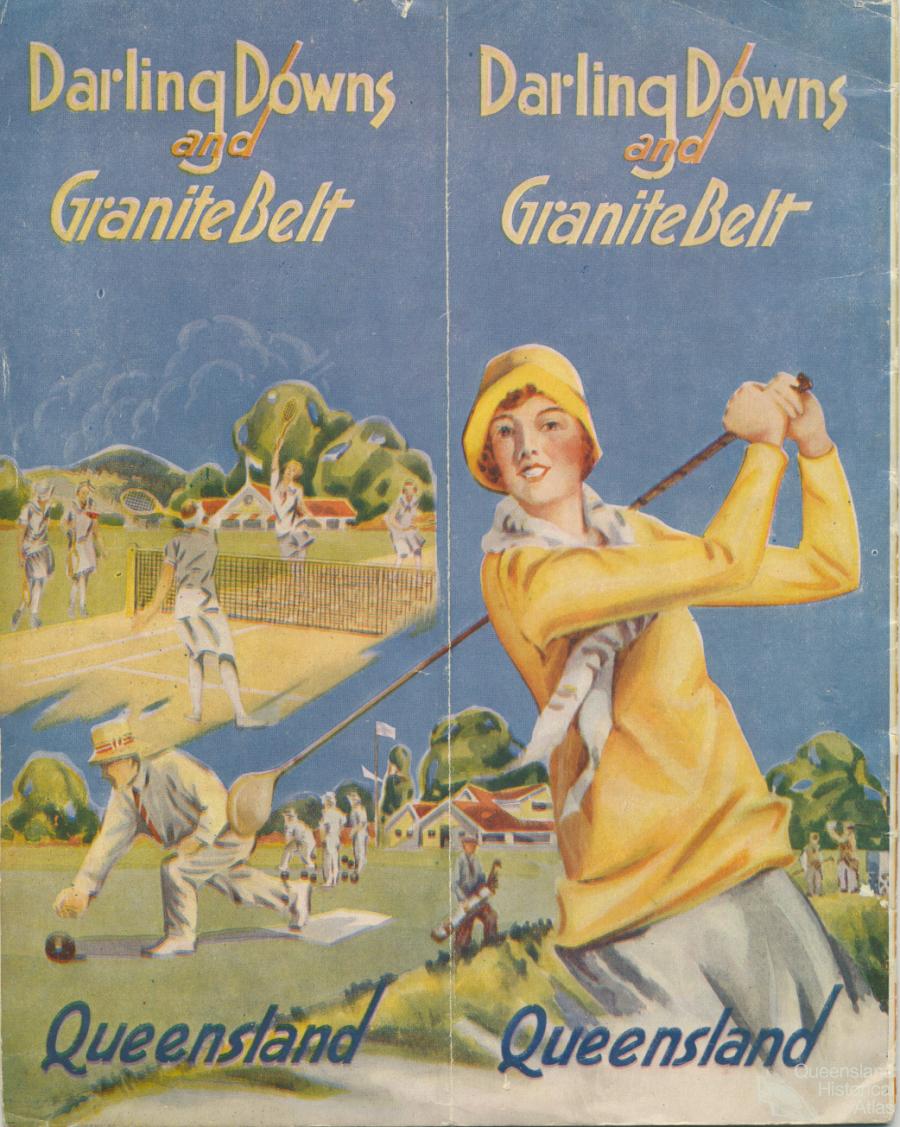
By the end of the nineteenth century the region became known as ‘The Garden of Queensland’. Pastoral villages were replaced by the large service towns of Warwick, Dalby, Pittsworth and, above all, Toowoomba which evolved as the regional capital – the ‘Queenly City’ or the ‘Simla of Queensland’; summer home for the colony’s governors.
Dairying dominated the Downs’ economy between the world wars – in the 1930s there were about 6500 dairy farms with an average of 30 cows each – and the cream cheque saved many a farm and town in the Great Depression. However, wheat (and other cereal crops) also boomed, despite falling prices; broad-acre farming with large combine harvesters appeared in the landscape. Unfortunately also so did the intrusive prickly pear until eradicated by the Argentinean parasite cactoblastis cactorum. Government-sponsored soldier settlement schemes on marginal lands were mostly a disaster, except in the Granite Belt which diversified into fruit growing.
During World War II, the Downs landscape was dotted with military airfields, especially at Oakey, Cecil Plains and Leyburn the last of which was the training field for Z Force. Toowoomba – headquarters for General Lavarack – also became an ‘R & R base’ for American service personnel. A signal station at Cabarlah, a RAAF Stores Depot for Toowoomba and Oakey Army Aviation Field would remain as important post-war national defence installations and regional economic inputs.
Grand schemes
Post-war, dairying and wheat continued their domination, although large wheat fields were now varied by safflower, sunflower and sorghum. Sealed roads rendered the rail network superfluous; most tracks were pulled up. Rural electrification saw poles and wires strung across open plains. Economic forces mandated the replacement of small family farming with larger commercial farms; ring dams and concrete wheat silos dominated the scene while cotton grew on the Cecil Plains. By century’s end rationalisation had completely gutted the regional dairying industry and globalization forced the closure of many associated factories. Moreover, the long century-end drought posed major challenges for local governments with dam levels falling alarmingly just as the north-western Downs landscape has seen the development of water-intensive coal-mining and coal-seam gas power generators.
Art of the Darling Downs region
In the mid-nineteenth century the Downs was visited by artists such as Conrad Martens, JG Sawkins and HG Lloyd who, mainly executing pictures for squatters, generally gave the landscape an English park-like appearance indicating the region’s transformation from wilderness to civilisation under white tutelage. The quintessential Downs (farming) landscape was first captured in the water colours of Millmerran farmer Kenneth Macqueen (1897-1960) and then further illustrated in the works of Toowoomba artists Herb Carstens (1904-78), Don Featherstone (1902-84) and Ralph Weppner (1903-61). It has been reinterpreted by artists such as Maryika Welter.
Literature of the Darling Downs region
The Downs’ most influential writer was public servant and farmer Arthur Hoey Davis (1868-1935) who as Steele Rudd produced the comic Dad & Dave stories encapsulating the tribulation and triumph of selectors from struggling with drought to entering politics. Transferred to film and radio, Dad & Dave became Australian icons. Another public servant, George Essex Evans (1863-1909) gained national prominence at the time of Federation for his poetry eulogising the ‘women of the west’ and the coming Commonwealth; he was a strong advocate for the region and founded the Austral Association for the advancement of science and the arts. Literary journalist David Rowbotham’s (1924-) poetry celebrates the rural Downs as his ‘spirit-place’ and Jean Kent (1951-) elicits the appeal of regional identity, but national poet Bruce Dawe (1930-) offers a more acerbic view of provincial Toowoomba and novelist Andrew McGahan’s The white earth (2004) exposes a darker side of regional life.
References and Further reading (Note):
Maurice French and Duncan Waterson, The Darling Downs: A Pictorial History 1850-1950, Toowoomba, Darling Downs Institute Press, 1982
References and Further reading (Note):
Maurice French, Travelers in a landscape: visitors’ impressions of the Darling Downs 1827-1954, Toowoomba, USQ Press, 1994
References and Further reading (Note):
Patrick Buckridge and Belinda McKay (eds), By the book: a literary history of Queensland, St Lucia, UQP 2007
References and Further reading (Note):
Noni Durack and Pamela King, Downs artists: a changing landscape, Toowoomba, Darling Downs Institute Press, 1985
THEY left the vine-wreathed cottage and the mansion on the hill,
The houses in the busy streets where life is never still,
The pleasures of the city, and the friends they cherished best:
For love they faced the wilderness - the Women of the West.
The roar, and rush, and fever of the city died away,
And the old-time joys and faces-they were gone for many a day;
In their place the lurching coach-wheel, or the creaking bullock chains,
O'er the everlasting sameness of the never ending plains.
In the slab-built, zinc-roofed homestead of some lately-taken run,
In the tent beside the bankment of a railway just begun,
In the huts on new selections, in the camps of man's unrest,
On the frontiers of the Nation, live the Women of the West.
The red sun robs their beauty, and, in weariness and pain,
The slow years steal the nameless grace that never comes again;
And there are hours men cannot soothe, and words men cannot say -
The nearest woman's face may be a hundred miles away.
The wide Bush holds the secrets of their longings and desires,
When the white stars in reverence light their holy altar-fires,
And silence, like the touch of God, sinks deep into the breast -
Perchance He hears and understands the Women of the West.
For them no trumpet sounds the call, no poet plies his arts -
They only hear the beating of their gallant, loving hearts.
But they have sung with silent lives the song all songs above -
The holiness of sacrifice, the dignity of love.
Well have we held our fathers' creed. No call has passed us by.
We faced and fought the wilderness, we sent our sons to die.
And we have hearts to do and dare, and yet, o'er all the rest,
The hearts that made the Nation were the Women of the West.
From: George Essex Evans, The secret key and other verses, Angus & Robertson, Sydney 1906
“Have you heard tell yet,” said Sam, “of the new
country to the north, they call the Darling Downs?”
“I have heard of it, from Burnside the cattle dealer.
He describes it as a paradise of wealth.”
“He is right. When you get through the Cypress,
the plains are endless. It is undoubtedly the finest
piece of country found yet.”
DAD used to say that Shingle Hut was the finest selection on Darling Downs; but we never could see anything fine about it—except the weather in drought time, or Dad's old saddle mare. She was very fine. The house was built in a gully so that the bailiffs (I suppose) or the blacks—who were mostly dead—couldn't locate it. An old wire-fence, slanting all directions, staggered past the front door. At the rear, its foot almost in the back door, sloped a barren ridge, formerly a squatter's sheep-yard. For the rest there were sky, wallaby-scrub, gum-trees, and some acres of cultivation. But Dad must have seen something in it, or he wouldn't have stood feasting his eyes on the wooded waste after he had knocked off work of an evening. In all his wanderings—and Dad had been almost everywhere; swimming flooded creeks and rivers, humping his swag from one end of Australia to the other;! at all games going except bank-managing and bushranging—he had seen no place timbered like Shingle Hut.
“Why,” he used to say, “it's a fortune in itself. Hold on till the country gets populated, and firewood is scarce, there'll be money in it then—mark my words!”
Poor Dad! I wonder how long he expected to live?
At the back of Shingle Hut was a tract of Government land—mostly mountains—marked on the map as the Great Dividing Range. Splendid country, Dad considered it— beautiful country—and part of a grand scheme he had in his head. I defy you to find a man more full of schemes than Dad was.
So, needs-must, we had to hold on our course, away to the North, hugging the edge of the waterless country, up Gobang Creek, by Harvey's Range and Buckinbah, till we crossed the Macquarie, and struck along the Talbragar for the northern line, passing Liverpool Plains and skirting the New England Table-land, till we found ourselves on the margin of a tract of unsurpassed beauty and luxuriance—a black upland, swathed in flower-specked emerald, swelling away North in rolling seas of grass, spotted with misty islets; for many a mile without mark of hoof or other sign of the white man—and that was Darling Downs.
The elevation of Darling Downs—about 1800 to 2000 feet, according to the barometrical observations of Mr. Cunningham—renders the climate much cooler than its latitude would lead one to suppose; indeed, ice has frequently been found, during the calm clear nights of winter. During September and October, we observed at sunrise an almost perfect calm. About nine o'clock, light westerly winds set in, which increased towards noon, died away towards evening, and after sunset, were succeeded by light easterly breezes; thunder-storms rose from south and south-west, and passed over with a violent gust of wind and heavy showers of rain; frequently, in half an hour's time, the sky was entirely clear again; sometimes, however, the night and following day were cloudy.
The plains, as we passed, were covered with the most luxuriant grass and herbage. Plants of the leguminosae and compositae, were by far the most prevalent; the colour of the former, generally a showy red, that of the latter, a bright yellow. Belts of open forest land, principally composed of the Box-tree of the Colonists (a species of Eucalyptus), separate the different plains; and patches of scrub, consisting of several species of Acacias, and of a variety of small trees, appear to be the outposts of the extensive scrubs of the interior. There are particularly three species of Acacias, which bestow a peculiar character on these scrubs: the one is the Myal (A. pendula)—first seen by Oxley on Liverpool Plains, and afterwards at the Barwan, and which exists in all the western plains between the Barwan and Darling Downs—whose drooping foliage and rich yellow blossoms render it extremely elegant and ornamental. The second, the Acacia of Coxen, resembles the Myal (without its drooping character), its narrow lanceolate phyllodia rather stiff, its yellowish branches erect. The third, is the Bricklow Acacia, which seems to be identical with the Rose-wood Acacia of Moreton Bay; the latter, however, is a fine tree, 50 to 60 feet high, whereas the former is either a small tree or a shrub. I could not satisfactorily ascertain the origin of the word Bricklow,* but, as it is well understood and generally adopted by all the squatters between the Severn River and the Boyne, I shall make use of the name. Its long, slightly falcate leaves, being of a silvery green colour, give a peculiar character to the forest, where the tree abounds.