- Home
- Quintessential Queensland
- Distinctiveness
- Perceptions
- Perceptions: how people understand the landscape
- From runs to closer settlement
- Geological survey of Queensland
- Mapping a new colony, 1860-80
- Mapping the Torres Strait: from TI to Magani Malu and Zenadh Kes
- Order in Paradise: a colonial gold field
- Queensland atlas, 1865
- Queensland mapping since 1900
- Queensland: the slogan state
- Rainforests of North Queensland
- Walkabout
- Queenslanders
- Queenslanders: people in the landscape
- Aboriginal heroes: episodes in the colonial landscape
- Australian South Sea Islanders
- Cane fields and solidarity in the multiethnic north
- Chinatowns
- Colonial immigration to Queensland
- Greek Cafés in the landscape of Queensland
- Hispanics and human rights in Queensland’s public spaces
- Italians in north Queensland
- Lebanese in rural Queensland
- Queensland clothing
- Queensland for ‘the best kind of population, primary producers’
- Too remote, too primitive and too expensive: Scandinavian settlers in colonial Queensland
- Distance
- Movement
- Movement: how people move through the landscape
- Air travel in Queensland
- Bicycling through Brisbane, 1896
- Cobb & Co
- Journey to Hayman Island, 1938
- Law and story-strings
- Mobile kids: children’s explorations of Cherbourg
- Movable heritage of North Queensland
- Passages to India: military linkages with Queensland
- The Queen in Queensland, 1954
- Transient Chinese in colonial Queensland
- Travelling times by rail
- Pathways
- Pathways: how things move through the landscape and where they are made
- Aboriginal dreaming paths and trading ways
- Chinese traders in the nineteenth century
- Introducing the cane toad
- Pituri bag
- Press and the media
- Radio in Queensland
- Red Cross Society and World War I in Queensland
- The telephone in Queensland
- Where did the trams go?
- ‘A little bit of love for me and a murder for my old man’: the Queensland Bush Book Club
- Movement
- Division
- Separation
- Separation: divisions in the landscape
- Asylums in the landscape
- Brisbane River
- Changing landscape of radicalism
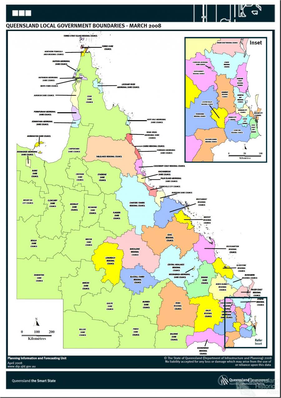
- Civil government boundaries
- Convict Brisbane
- Dividing Queensland - Pauline Hanson’s One Nation Party
- High water mark: the shifting electoral landscape 2001-12
- Hospitals in the landscape
- Indigenous health
- Palm Island
- Secession movements
- Separate spheres: gender and dress codes
- Separating land, separating culture
- Stone walls do a prison make: law on the landscape
- The 1967 Referendum – the State comes together?
- Utopian communities
- Whiteness in the tropics
- Conflict
- Conflict: how people contest the landscape
- A tale of two elections – One Nation and political protest
- Battle of Brisbane – Australian masculinity under threat
- Dangerous spaces - youth politics in Brisbane, 1960s-70s
- Fortress Queensland 1942-45
- Grassy hills: colonial defence and coastal forts
- Great Shearers’ Strike of 1891
- Iwasaki project
- Johannes Bjelke-Petersen: straddling a barbed wire fence
- Mount Etna: Queensland's longest environmental conflict
- Native Police
- Skyrail Cairns (Research notes)
- Staunch but conservative – the trade union movement in Rockhampton
- The Chinese question
- Thomas Wentworth Wills and Cullin-la-ringo Station
- Separation
- Dreaming
- Imagination
- Imagination: how people have imagined Queensland
- Brisbane River and Moreton Bay: Thomas Welsby
- Changing views of the Glasshouse Mountains
- Imagining Queensland in film and television production
- Jacaranda
- Literary mapping of Brisbane in the 1990s
- Looking at Mount Coot-tha
- Mapping the Macqueen farm
- Mapping the mythic: Hugh Sawrey's ‘outback’
- People’s Republic of Woodford
- Poinsettia city: Brisbane’s flower
- The Pineapple Girl
- The writers of Tamborine Mountain
- Vance and Nettie Palmer
- Memory
- Memory: how people remember the landscape
- Anna Wickham: the memory of a moment
- Berajondo and Mill Point: remembering place and landscape
- Cemeteries in the landscape
- Landscapes of memory: Tjapukai Dance Theatre and Laura Festival
- Monuments and memory: T.J. Byrnes and T.J. Ryan
- Out where the dead towns lie
- Queensland in miniature: the Brisbane Exhibition
- Roadside ++++ memorials
- Shipwrecks as graves
- The Dame in the tropics: Nellie Melba
- Tinnenburra
- Vanished heritage
- War memorials
- Curiosity
- Curiosity: knowledge through the landscape
- A playground for science: Great Barrier Reef
- Duboisia hopwoodii: a colonial curiosity
- Great Artesian Basin: water from deeper down
- In search of Landsborough
- James Cook’s hundred days in Queensland
- Mutual curiosity – Aboriginal people and explorers
- Queensland Acclimatisation Society
- Queensland’s own sea monster: a curious tale of loss and regret
- St Lucia: degrees of landscape
- Townsville’s Mount St John Zoo
- Imagination
- Development
- Exploitation
- Transformation
- Transformation: how the landscape has changed and been modified
- Cultivation
- Empire and agribusiness: the Australian Mercantile Land and Finance Company
- Gold
- Kill, cure, or strangle: Atherton Tablelands
- National parks in Queensland
- Pastoralism 1860s–1915
- Prickly pear
- Repurchasing estates: the transformation of Durundur
- Soil
- Sugar
- Sunshine Coast
- The Brigalow
- Walter Reid Cultural Centre, Rockhampton: back again
- Survival
- Survival: how the landscape impacts on people
- Brisbane floods: 1893 to the summer of sorrow
- City of the Damned: how the media embraced the Brisbane floods
- Depression era
- Did Clem Jones save Brisbane from flood?
- Droughts and floods and rail
- Missions and reserves
- Queensland British Food Corporation
- Rockhampton’s great flood of 1918
- Station homesteads
- Tropical cyclones
- Wreck of the Quetta
- Pleasure
- Pleasure: how people enjoy the landscape
- Bushwalking in Queensland
- Cherbourg that’s my home: celebrating landscape through song
- Creating rural attractions
- Festivals
- Queer pleasure: masculinity, male homosexuality and public space
- Railway refreshment rooms
- Regional cinema
- Schoolies week: a festival of misrule
- The sporting landscape
- Visiting the Great Barrier Reef
By:
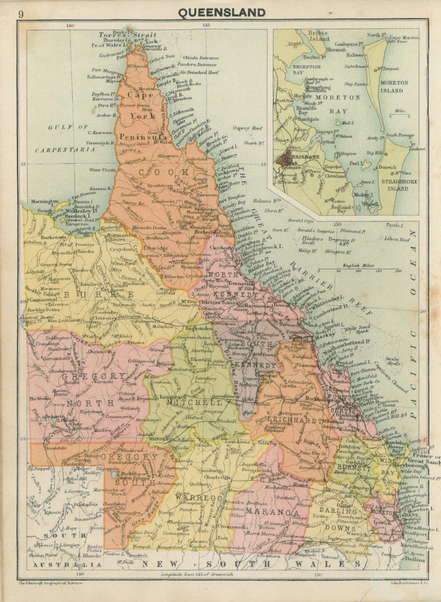
John Young By the 1850s Queensland’s greatest value to colonists was the pastoral potential of its land, all of which had been claimed by the British Crown. For the purpose of land survey and management the New South Wales government divided Queensland into twelve districts. At the granting of responsible government in 1859 most of the districts were designated as ‘unsettled’; the ‘settled’ ones being Moreton (Brisbane region), Port Curtis (Gladstone region), and Wide Bay (Maryborough region); the districts of Darling Downs and Burnett (Gayndah region) were partly settled and unsettled.
Pastoral occupation and land clearing were so imprinted on Queensland that the settled and unsettled districts continued to be shown in standard atlas maps into the twentieth century. They are shown thus on the map taken from J.G. Bartholomew’s Royal Australasian World Atlas, c1900. Municipal and shire boundaries had neither the simplicity nor popular recognition of the twelve districts.
Towns
Local government in Queensland began in 1859 with the creation of the town of Brisbane. Subsequent towns and boroughs were Ipswich, Rockhampton and Toowoomba (1860), Maryborough and Warwick (1861), Bowen, Dalby and Gladstone (1863), Gayndah and Townsville (1866), Clermont and Roma (1867), Allora and Mackay (1869). These municipalities came from local voluntary impulses, aided by colonial legislation. The rest of the colony was devoid of local government, and looked like staying that way unless prodded into action.
Divisions
Premier Charles Lilley proposed in 1869 that the twelve districts become local government bodies, but that Moreton, Darling Downs, Leichhardt and Kennedy be divided into ‘East’ and ‘West’ or ‘North’ and ‘South’. (By 2001 East and West Moreton would have had 70% of Queensland’s population.) Lilley’s idea lapsed. In 1879 voluntary local government was replaced with compulsion, with the colonial government empowering itself to create local government divisions in rural Queensland. Existing municipal towns were left alone. On 11 November 1879, 65 divisions were created, all in haste. Lacking data about communities of interest or practical municipal boundaries, the Lands Commissioners offered the census districts as a template. Booroodabin (Fortitude Valley) of three square miles and Woolloongabba of four square miles were each made a division, as was Diamantina of nearly 40,000 square miles. There were also small divisions around Ipswich, Toowoomba and Beenleigh.
Restyled as shires
In 1902 the divisions were restyled as shires, and in all the municipalities numbered four cities, 29 towns and 127 shires. During 1916-19 the Ryan Labour government embarked on local government amalgamations at Charters Towers, Maryborough, Ipswich, Toowoomba, Bundaberg and Rockhampton. The biggest change was in the Ipswich area where Bundamba, Lowood, Purga and Walloon were amalgamated as Moreton Shire; Brassall was added to Ipswich City. A more spectacular reform came in 1925 when the Theodore Labour government amalgamated the City of South Brisbane, six towns, ten shires and parts of two other shires with the City of Brisbane, the only local government authority in the state to have its own Act of Parliament.
Hived off
In the far north at Cairns, Cooktown and their hinterland, there had been a splitting up of the original (1879) divisions when mining towns grew and agriculture intensified. The 1879 divisions were Cairns, Hann (Maytown and the Palmer River goldfields), Woothakata (Thounborough, Hodgkinson River goldfield), Einasleigh (Georgetown, Etheridge goldfield) and Daintree (Cooktown). During 1880-1910 six new divisions and towns were hived off from three of the original divisions: Douglas (1880); Tinaroo (1881) based at Atherton; Cairns borough (1885); Walsh (1889) based at Montalbion and Irvinebank; Barron (1890) based at Cairns; Chillagoe (1908); Eacham (1910) based at Malanda.
Beginning in 1919, the process went into reverse when Barron Shire was abolished and divided between Cairns and Woothakata. Next year Hann Shire was amalgamated with Daintree Shire and Cooktown, forming Cook Shire. In 1932 Woothakata Shire absorbed Chillagoe and Walsh shires. Its name was changed to Mareeba in 1947.
Absorbed
In 1995 Cairns City absorbed its surrounding shire (originally named Cairns but renamed Mulgrave in 1940). Mulgrave Shire (1737 square kilometres) had a substantial urban population, and increased Cairns City’s from 43,000 to over 100,000 after amalgamation. In the amalgamations in 2008 Douglas Shire was united with Cairns City and Atherton; Eacham, Herberton and Mareeba Shires were amalgamated as Tablelands Regional Council. In the far north there had been a return to the pattern set in 1879: for Cairns and Douglas divisions, Cairns City; for Woothakata division, Tablelands Regional Council; for Hann and Daintree divisions, Cook Shire; and Einasleigh division, renamed Etheridge, remained as Etheridge Shire.
Around Townsville there was a different story. Townsville borough (1866) originally had less than four square miles, and pressing in on all sides there was Thuringowa division (1879), an area of nearly 3000 square miles. As Townsville’s urban growth spilled into Thuringowa, a piece or pieces were added to Townsville; Belgian Gardens, for example, was in Thuringowa until 1918. The boundary changes, however, did not keep up with urban growth, and Thuringowa was restyled as a city in 1986. In 2008 both cities were amalgamated.
When local government divisions were proclaimed for the Darling Downs there were six. In 1913-14 the smallest, Gowrie (23 square miles) was abolished, but four more were created by excisions from those remaining. The number had been whittled down to seven by 2008, and they were bundled into one with Toowoomba. So influential was Toowoomba on the region, the new council was named not Darling Downs but Toowoomba Regional Council.
Hotly contested council amalgamations
In 1900 a map of Queensland’s local government looked like an assemblage of outback spaces and coastal fly specks. By mid-century many of the fly specks had been removed. But inhabitants had grown used to their local government areas, even if some had come from nineteenth century census districts. The hotly contested amalgamations by the Beattie Labor Government in 2008 made for a simpler map, more than halving the number of councils from 157 to 73, but in many places they lacked public acceptance. Isisford Shire (population 262) steadfastly asserted its right to continue, but it was amalgamated with Ilfracombe and Longreach Shires. Barcoo Shire with 360 inhabitants, but vaster and more remote, continued.
References and Further reading (Note):
Report of the Local Government Reform Commission, 2007
References and Further reading (Note):
Queensland Year Books (and preceding Statistical Registers)
References and Further reading (Note):
Post office directories (1885-1949)
References and Further reading (Note):
Australian Blue Book (1949)
Keywords:
amalgamation, boundaries, council, councils, districts, land, local government, settled, settlement, shires, unsettled