- Home
- Quintessential Queensland
- Distinctiveness
- Perceptions
- Perceptions: how people understand the landscape
- From runs to closer settlement
- Geological survey of Queensland
- Mapping a new colony, 1860-80
- Mapping the Torres Strait: from TI to Magani Malu and Zenadh Kes
- Order in Paradise: a colonial gold field
- Queensland atlas, 1865
- Queensland mapping since 1900
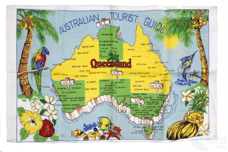
- Queensland: the slogan state
- Rainforests of North Queensland
- Walkabout
- Queenslanders
- Queenslanders: people in the landscape
- Aboriginal heroes: episodes in the colonial landscape
- Australian South Sea Islanders
- Cane fields and solidarity in the multiethnic north
- Chinatowns
- Colonial immigration to Queensland
- Greek Cafés in the landscape of Queensland
- Hispanics and human rights in Queensland’s public spaces
- Italians in north Queensland
- Lebanese in rural Queensland
- Queensland clothing
- Queensland for ‘the best kind of population, primary producers’
- Too remote, too primitive and too expensive: Scandinavian settlers in colonial Queensland
- Distance
- Movement
- Movement: how people move through the landscape
- Air travel in Queensland
- Bicycling through Brisbane, 1896
- Cobb & Co
- Journey to Hayman Island, 1938
- Law and story-strings
- Mobile kids: children’s explorations of Cherbourg
- Movable heritage of North Queensland
- Passages to India: military linkages with Queensland
- The Queen in Queensland, 1954
- Transient Chinese in colonial Queensland
- Travelling times by rail
- Pathways
- Pathways: how things move through the landscape and where they are made
- Aboriginal dreaming paths and trading ways
- Chinese traders in the nineteenth century
- Introducing the cane toad
- Pituri bag
- Press and the media
- Radio in Queensland
- Red Cross Society and World War I in Queensland
- The telephone in Queensland
- Where did the trams go?
- ‘A little bit of love for me and a murder for my old man’: the Queensland Bush Book Club
- Movement
- Division
- Separation
- Separation: divisions in the landscape
- Asylums in the landscape
- Brisbane River
- Changing landscape of radicalism
- Civil government boundaries
- Convict Brisbane
- Dividing Queensland - Pauline Hanson’s One Nation Party
- High water mark: the shifting electoral landscape 2001-12
- Hospitals in the landscape
- Indigenous health
- Palm Island
- Secession movements
- Separate spheres: gender and dress codes
- Separating land, separating culture
- Stone walls do a prison make: law on the landscape
- The 1967 Referendum – the State comes together?
- Utopian communities
- Whiteness in the tropics
- Conflict
- Conflict: how people contest the landscape
- A tale of two elections – One Nation and political protest
- Battle of Brisbane – Australian masculinity under threat
- Dangerous spaces - youth politics in Brisbane, 1960s-70s
- Fortress Queensland 1942-45
- Grassy hills: colonial defence and coastal forts
- Great Shearers’ Strike of 1891
- Iwasaki project
- Johannes Bjelke-Petersen: straddling a barbed wire fence
- Mount Etna: Queensland's longest environmental conflict
- Native Police
- Skyrail Cairns (Research notes)
- Staunch but conservative – the trade union movement in Rockhampton
- The Chinese question
- Thomas Wentworth Wills and Cullin-la-ringo Station
- Separation
- Dreaming
- Imagination
- Imagination: how people have imagined Queensland
- Brisbane River and Moreton Bay: Thomas Welsby
- Changing views of the Glasshouse Mountains
- Imagining Queensland in film and television production
- Jacaranda
- Literary mapping of Brisbane in the 1990s
- Looking at Mount Coot-tha
- Mapping the Macqueen farm
- Mapping the mythic: Hugh Sawrey's ‘outback’
- People’s Republic of Woodford
- Poinsettia city: Brisbane’s flower
- The Pineapple Girl
- The writers of Tamborine Mountain
- Vance and Nettie Palmer
- Memory
- Memory: how people remember the landscape
- Anna Wickham: the memory of a moment
- Berajondo and Mill Point: remembering place and landscape
- Cemeteries in the landscape
- Landscapes of memory: Tjapukai Dance Theatre and Laura Festival
- Monuments and memory: T.J. Byrnes and T.J. Ryan
- Out where the dead towns lie
- Queensland in miniature: the Brisbane Exhibition
- Roadside ++++ memorials
- Shipwrecks as graves
- The Dame in the tropics: Nellie Melba
- Tinnenburra
- Vanished heritage
- War memorials
- Curiosity
- Curiosity: knowledge through the landscape
- A playground for science: Great Barrier Reef
- Duboisia hopwoodii: a colonial curiosity
- Great Artesian Basin: water from deeper down
- In search of Landsborough
- James Cook’s hundred days in Queensland
- Mutual curiosity – Aboriginal people and explorers
- Queensland Acclimatisation Society
- Queensland’s own sea monster: a curious tale of loss and regret
- St Lucia: degrees of landscape
- Townsville’s Mount St John Zoo
- Imagination
- Development
- Exploitation
- Transformation
- Transformation: how the landscape has changed and been modified
- Cultivation
- Empire and agribusiness: the Australian Mercantile Land and Finance Company
- Gold
- Kill, cure, or strangle: Atherton Tablelands
- National parks in Queensland
- Pastoralism 1860s–1915
- Prickly pear
- Repurchasing estates: the transformation of Durundur
- Soil
- Sugar
- Sunshine Coast
- The Brigalow
- Walter Reid Cultural Centre, Rockhampton: back again
- Survival
- Survival: how the landscape impacts on people
- Brisbane floods: 1893 to the summer of sorrow
- City of the Damned: how the media embraced the Brisbane floods
- Depression era
- Did Clem Jones save Brisbane from flood?
- Droughts and floods and rail
- Missions and reserves
- Queensland British Food Corporation
- Rockhampton’s great flood of 1918
- Station homesteads
- Tropical cyclones
- Wreck of the Quetta
- Pleasure
- Pleasure: how people enjoy the landscape
- Bushwalking in Queensland
- Cherbourg that’s my home: celebrating landscape through song
- Creating rural attractions
- Festivals
- Queer pleasure: masculinity, male homosexuality and public space
- Railway refreshment rooms
- Regional cinema
- Schoolies week: a festival of misrule
- The sporting landscape
- Visiting the Great Barrier Reef
By:
Peter Spearritt Is Queensland different? Are there aspects of its culture and landscape that are unmistakeably Queensland? What is distinctive about Queensland? These questions are answered in a variety of ways in the opening contributions to this historical atlas. Queensland itself has an unusual shape; its long coastline looks to the Pacific Ocean in the east and New Guinea to its north. Many people do not realise that Queensland also includes over 100 islands in the Torres Straits, seventeen of which are inhabited.
The parcel of land that is today called Queensland has seen human habitation for tens of thousands of years. The continental islands of the Torres Strait, created by rising sea levels, were once part of the landmass. It is quite a shock to visit some of the larger islands, such as the Prince of Wales Island, and turning your back to the shoreline find yourself in what we would normally regard as the Australian bush. That’s what it is, with water around it. Perhaps one day the canal estates on the Gold Coast, as sea levels rise, will become a latter-day Atlantis, and visitors will be able to view submerged mansions from a glass-bottomed boat, evidence of a previous civilisation.
Queensland confronts us with an extraordinary array of landscapes and ecological regions, from the sparse vegetation of the Gulf Country to remnant luxuriant rainforests, from the Daintree River to the Mary Cairncross Park near Maleny, overlooking the Glasshouse Mountains. Daintree River cruises now cater to tourists anxious to see a crocodile outside captivity, while the tiny Mary Cairncross Park is a stark reminder that most of Queensland’s rainforests were so aggressively logged in the nineteenth and early twentieth centuries that not much is left. In 1913 the English writer Rider Haggard, on a lecture tour of Australia, wrote in the Brisbane Courier that in Queensland ‘majestic timber sufficient to supply the world with furniture woods for years to come’ had been ‘ruthlessly hacked down’ and the residue fired for farmers to grow crops. If it wasn’t for a committed band of environmentalists in the early decades of the twentieth century, we would not today be able to enjoy the Lamington National Park or dozens of other sites where they managed to convince the State government that at least some of Queensland’s distinctive landscapes should be preserved from development.
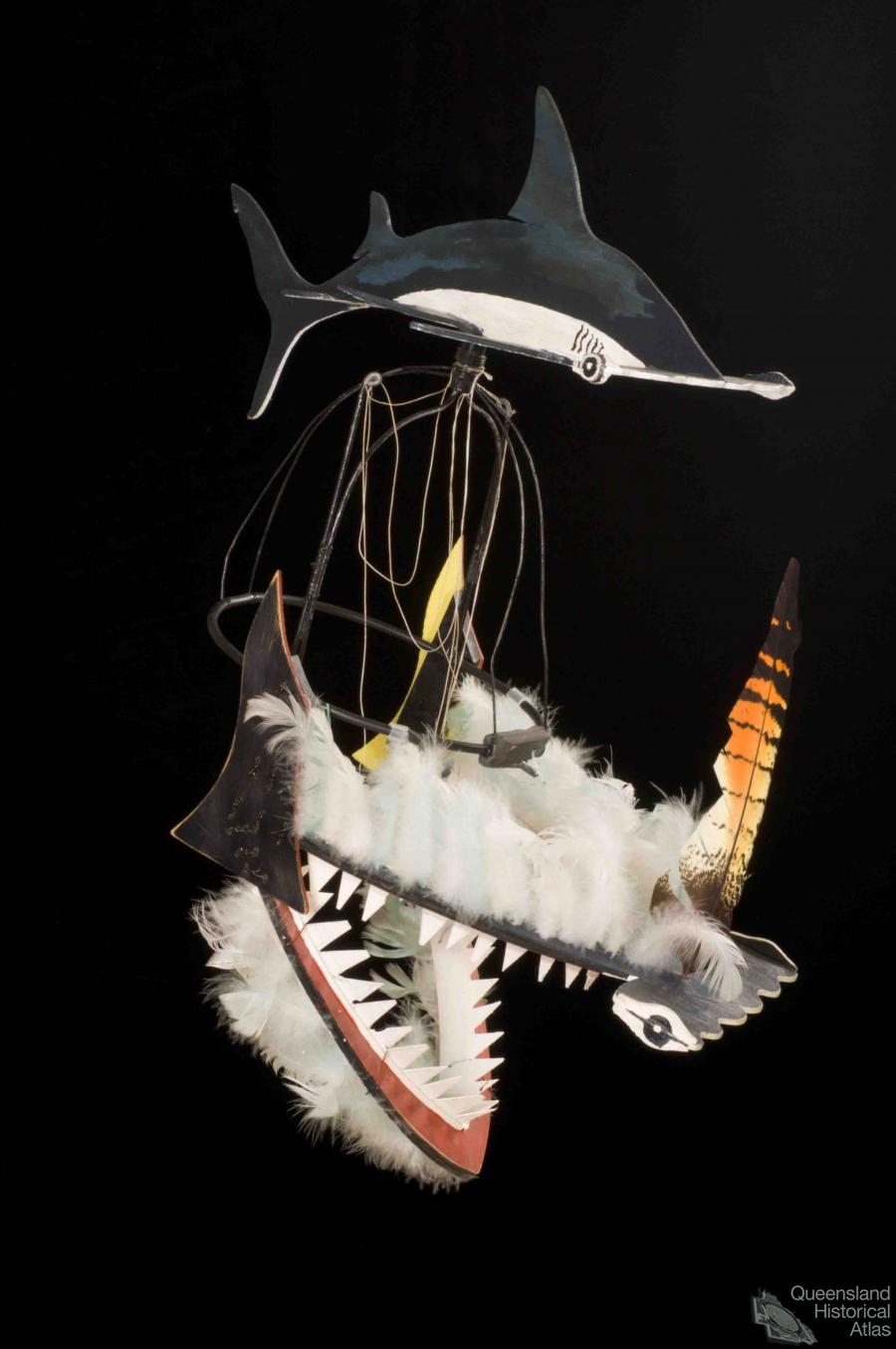
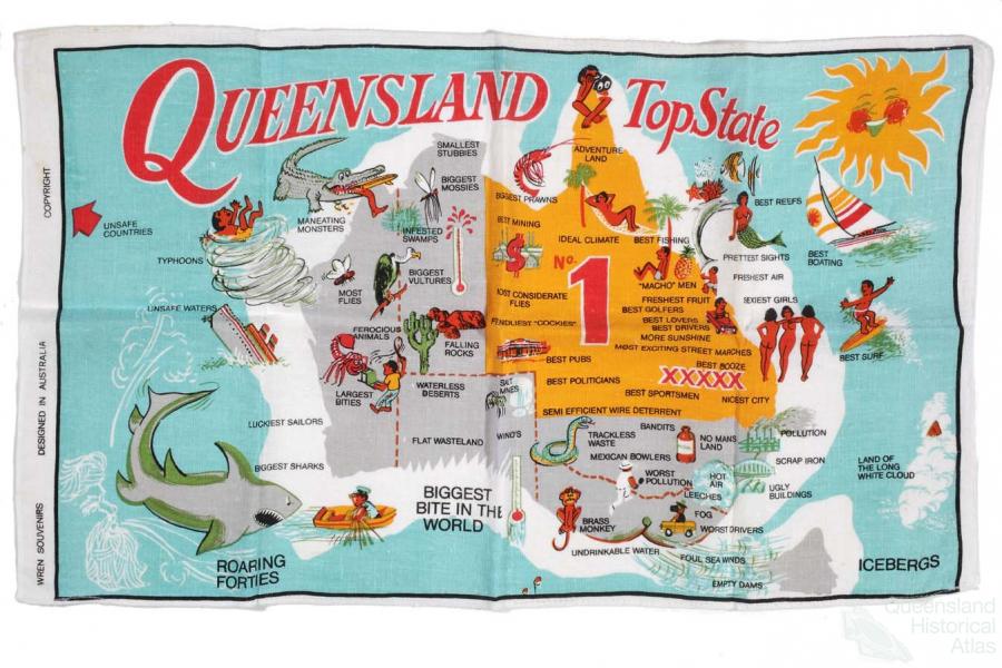
One of the ways in which Queensland is distinctive is that it has a smaller proportion of its landmass held in national parks than any other state in Australia. In the twentieth century Queensland often suffered from such interstate comparisons in both its physical and its cultural landscapes, from tree clearing to high school completions. In the era of the Bjelke Petersen premiership, Queensland was regularly derided in the other states, but it fought back in true populist fashion via tea towels proclaiming that everything about Queensland was good – from Flo’s pumpkin scones to a pliant workforce. Other states were depicted as full of striking unionists, lurking sharks – as if Queensland was shark free – whingers and bludgers.
We all have different ways of judging what we think is distinctive about a place. This will depend on our background, life experience and age. In my own lifetime I have seen more changes to the cultural and physical landscape of Queensland than anywhere else in Australia. At the age of six I was transported for a year, through family circumstance, from a brand new suburb of Melbourne to Gympie. At my Melbourne primary school there were 60 kids in the class, but they all wore shoes, no matter how poor they were. In Gympie the class size was smaller, but half the class didn’t wear shoes, some through poverty, others through choice. Not wearing shoes to school seemed to me very distinctive. As my maternal grandfather was the local Ford dealer, he could afford a house above the Mary Street flood line, from which, in the spectacular floods of 1955, the local kids could enjoy the spectacle of the flotsam and jetsam that a flood creates. Thereafter I always associated Queensland with floods, so the long drought early in the twenty-first century came as a shock.
In 1944 my grandfather bought a ginger farm at Buderim, and in the 1950s and 1960s we made an annual trek from Melbourne to Buderim for the Christmas holidays. Next door a banana plantation, full of dark places, carpet snakes and wooden drying rooms proved popular with kids because it was so spooky. Local workers loved to show what they could do with a machete, from cutting down a bunch of bananas to dispatching a snake. The township, dominated by the CWA, the primary school, the butcher who did his own slaughtering, the ginger factory, and Middleton’s general store, quickly succumbed to a change in both its physical and its cultural landscape. Alfred Grant Pty Ltd purchased the banana plantation in 1960 and the ‘Belle Vue’ estate became the first large residential subdivision on Buderim. Retirees from Queensland and the southern states embraced good breezes and the rich volcanic soil. Their gardens flourished and the town grew. Buderim didn’t put up much of a fight against its Woolworths, erected in the 1990s, but it has managed to retain some of its nineteenth and early twentieth century wooden buildings. Some of the State’s country towns have retained their two storey wooden hotels with their shady verandahs, from Pomona to Mossman, but in many of the larger towns these have given way to the single storey, warehouse style architecture of modern commerce. They now look just like country towns anywhere in Australia.
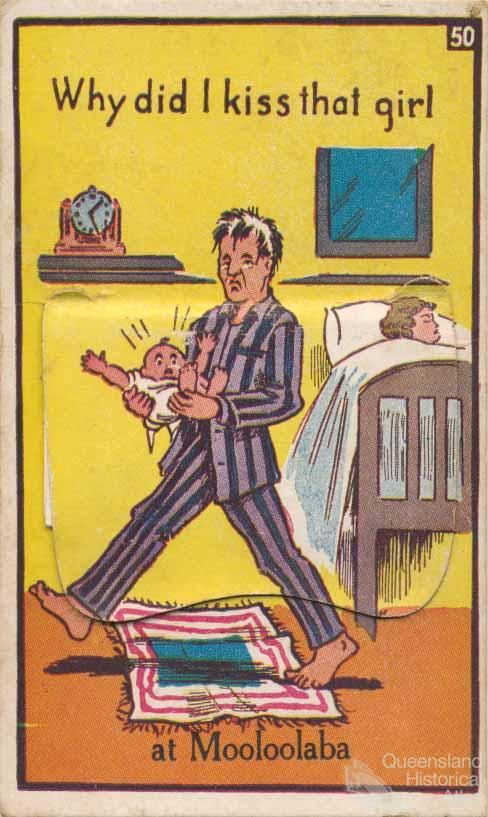
In the 1950s and 1960s the fibro picture theatre still operated at Mooloolaba and holiday makers flocked to huge camping grounds on the shoreline and on the river. My parents-to-be had met there while playing beach volleyball on Mooloolaba in 1946. As a child, Queensland appeared as a site of endless farms and holiday making. As soon as we passed, on our annual trek, through the art deco portal of the Hornibrook Highway we knew that Tibrogargan would be next, hovering over the road before Buderim, where the grandparental home overlooked sugar cane plantations all the way to Coolum. Shopping in Nambour in the cane cutting season came with the extra thrill of seeing the cane tram in the main street.
We regularly visited relatives on nearby and more distant farms, from a pineapple farm at Woombye to duboisia plantations at Boondooma. Though a keen farmer, my maternal grandfather could see that there was also money to be made out of subdividing land, from his ginger farm at Buderim to equally desirable sites at Maleny. His subdivision at Sippy Creek is near where the University of the Sunshine Coast now stands, not quite as near the surf as its highway billboard advertising of mortar board and beach towel would have prospective students believe.
My paternal grandparents lived in Woolloongabba, near the family bakery, having moved from a depopulated Cooktown, after my grandfather returned from the Great War to Bundaberg and thence to Brisbane. By then my family had moved to Sydney. As a teenager in the 1960s Brisbane seemed so dull and backward that is was almost exotic. Trams still plied the streets – Sydney had got rid of its trams – and suburban trains were pulled by steam engines. Sydney and Melbourne had gone electric in the 1920s. The wooden houses in Woolloongabba were decrepit. Many were rented and most hadn’t had a coat of paint in decades. The local community revolved around the pubs and the fiveways at Woolloongabba. Cricketers playing at the Gabba would bunk down on my grandparents’ front verandah at a modest weekly rate. These 1880s houses seemed ancient, especially to someone who had grown up amid brand new weatherboard and fibro houses in Melbourne and the brick houses of middle-class Sydney. And just up the hill loomed the Boggo Road gaol, discretely lit at night. Closed in the late 1990s, the gaol is still a memorable structure, despite the new ‘Ecosciences Precinct’ that now looms behind it.
Should distinctiveness be cherished? Some of Queensland’s settlements now celebrate their rich Aboriginal, Torres Strait or Islander heritage. And it is less common to find signs in the landscape that proclaim ‘first settled’ or ‘first explored’ or ‘first discovered’, referring to European colonisation. The success of Eddie Mabo in gaining recognition by the High Court of territorial rights accruing on the basis of many generations of occupancy has been a telling challenge to western notions of land ownership.
Much that was distinctive about Queensland has been lost. Most of its surf clubs, all still sitting on crown land leases, have been turned into sites for alcohol consumption and gaming, much like clubs anywhere else. The larger town centres, having survived the supermarket era, now find Bunnings and Office Works among the most notable structures on their peripheral landscapes. And even the capital city is in strife. There are remarkably few indications left that Brisbane was once a great river port. Wooden long shore wharves have been replaced by freeways and apartments. Brisbane is currently restoring its great City Hall, but the clocktower has long been overshadowed by high rise office blocks. The 1880s Yungaba migrant reception centre under the Storey Bridge has been on-sold to a development company half-owned by the Singapore Government. It is being redeveloped to provide apartments for the rich, as if the rich didn’t already have enough apartments to choose from. This disregard for history and heritage does not help Brisbane find a distinct image for itself, let alone compete with Melbourne’s trams or Sydney’s Bridge and Opera House.
This opening section of the Atlas includes articles on three of Queensland’s distinctive landscapes, the Torres Strait, the Channel Country and the Darling Downs. They could not be more different. The Darling Downs retains many of its grand pastoral mansions, even though some of the pastoralists have diversified into wine making. The Channel Country, ‘a desert that floods’, now finds itself the site of gas and oil exploration. And on Thursday Island, the recently opened Gab Titui Cultural Centre, records, explains and celebrates the rich history of the Torres Strait.
Queensland’s great natural landscapes can still celebrate their distinctiveness, but some, most notably the Great Barrier Reef, face huge ecological challenges, not least from global warming. The over-development of the coastal strip from Noosa to the Tweed River and the erosion of greenspace is one of the great tragedies of the last fifty years. The State government has attempted to monitor and reduce the time-honoured practice of tree clearing and not renew sand mining leases on Stradbroke Island, but many of the State’s national parks are still tiny and under pressure, including the Glasshouse Mountains where subdivision continues to encroach on the majesty of these great volcanic cores. Right now much of Queensland’s distinctiveness is under threat. This historical atlas – with its combination of maps, illustrations, objects and essays - can help readers appreciate the origins of that distinctiveness and the nature of the threats.
References and Further reading (Note):
Rider Haggard ‘Destruction of timber’, Brisbane Courier, 6 May 1913
References and Further reading (Note):
Peter Charlton State of mind: why Queensland is different, North Ryde, Methuen, 1983
References and Further reading (Note):
Humphrey McQueen, 'Queensland: a state of mind', Meanjin, 38/1, April 1979
References and Further reading (Note):
Julianne Schultz (ed), Hidden Queensland, Griffith review, 21, Spring 2008
References and Further reading (Note):
Bill Metcalf, 'Histories of Queensland', Queensland history journal, 21/3, 2010